English
  Português


In order to understand the city of Porto, we have to take into account its geographical location and go back thousands and thousands of years, to when it all began. Due to being part of the Iberian Peninsula (which encompasses Portugal, Spain, Andorra and Gibraltar), the first beings similar to man, the homo sapiens sapiens, arrived from the north of Africa, through the Straits of Gibraltar, and gradually spread out and inhabited Europe. During the Ice Age, many of these beings travelled south from Northern Europe, escaping the cold, dry climate.
When the first men began crossing Portugal and Spain, they searched for places with the right conditions for them to settle. They travelled up the Portuguese coast, staying close to the sea in order to escape the dense forests. Thousands and thousands of years ago, there were no airports, ports, motorways or trains... wherever they found the right conditions for survival, such as a good climate, proximity to the sea and the river, so that they could fish, or where there was fertile land for cultivation, that is where they would settle. Next to the coast and inland, the effect of the rivers produced plains, creating the right environment for man. Can you imagine living like that, without any means of transport or communication, no Internet or mobile phone, where all they had was the river, the sea and whatever they harvested from the land?
With regard to the Northern Region, which includes Porto (situated in the North West of Portugal and the second largest city in the country in terms of population), the people began settling there, thanks to the sea and especially the Douro River, which stretches for 850 kilometres. Porto’s history goes back further than many other European cities, as there are historical facts and archaeological findings that indicate that homo sapiens sapiens was present more than 20 thousand years ago in an area between the Alto Douro Wine Region and Vale do Côa.
Due to its special conditions, the banks of this river became the ideal place to live, as there was water to drink and fertile valleys for growing food, which guaranteed their survival. This has all been proven through the existence of Palaeolithic rock drawings and other archaeological findings dating back to around 20 thousand years ago, which were discovered along the Douro River, in Foz Côa, a city in the Alto Douro Wine Region.
26 kilometres of engravings and over one thousand engraved rocks have already been found in this region. The area between the Douro Wine Region and Vale do Côa is the biggest site in the world with this type of art from the Upper Palaeolithic, the time in which the homo sapiens sapiens came to Europe, around 40 thousand years ago.


8th Century B.C.
The birth of Porto as a city dates back to the Roman period, to the 8th century B.C. Celtic ruins have also been discovered in various areas. This city was under the remit of the Moors in 711, during the invasion of the Iberian Peninsula. In 868 it was called 'Cale' or 'Portus Cale', which later gave rise to the name Portugal. Vímara Peres, a warrior born in Galicia, went down in history as the founder of the County of Portugal and played a key role in conquering the land from the Moors. And that is how the city of 'Portucale' was re-conquered.
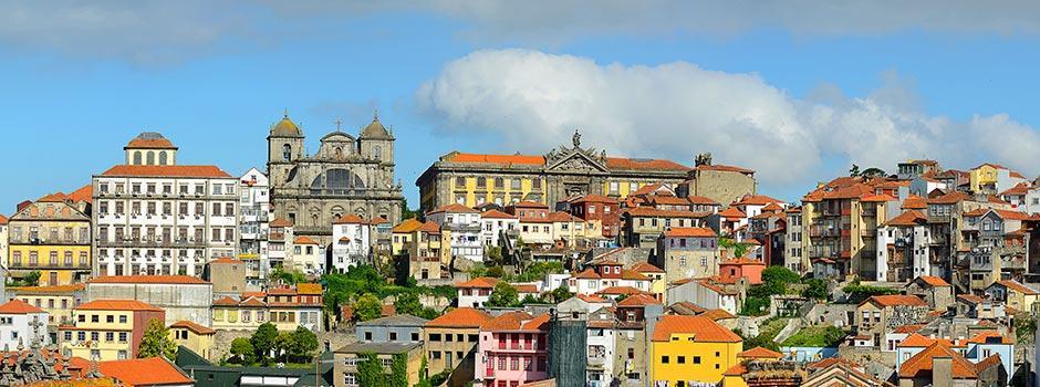
The Historic Centre of Porto is built upon granite, which gradually appeared throughout the city’s history, as it was used for building purposes. Although the word 'Portucale' has been given a variety of meanings, one of the explanations is that the word 'Cale', which meant 'stone, rock', was added to the Roman word 'Portus'.
The presence of granite is prolific, especially in parts of the historic centre of the city, which is denoted for the elegance and harmony resulting from the use of that stone, which can be found in buildings such as the Torre dos Clerigos, São Bento Railway Station, Terreiro da Sé and the Santo António General Hospital. However, it can also be seen on the slopes of the Douro vineyards, or even the city walls, which throughout history, have helped to shape the city.
12th Century (from 1101 to 1200)
Over time, the city of Porto began to be part of the trading route between Braga and Lisbon. In 1111, D. Teresa, the mother of D. Afonso Henriques, who was the first king of Portugal, handed over the 'land of Porto' to Bishop D. Hugo. The city's coat of arms includes a picture of Our Lady, which is why Porto is also known as the "City of the Virgin'. That bishop began building the Porto Cathedral, the dawn of the city's growth, which emerged from within the cathedral walls and gradually spread down to Ribeira (the riverside area). Once he was king, D. Afonso Henriques, son of Henry of Borgonha (Borgogne), reconquered the land south of Porto with the help of bishop Hugo.
13th Century (from 1201 to 1300)
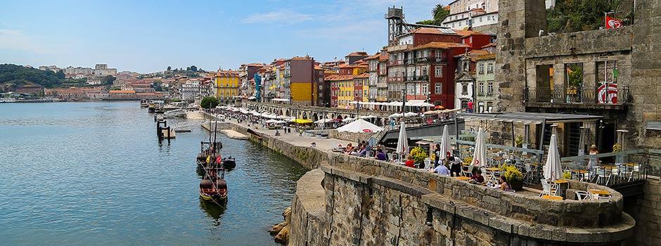
Dried fruit and olives and their derivatives were a significant part of the commerce in Porto and the Douro Valley region and were exported to various markets all over the world. However, the major boost in commercial relations was instigated with the Port wine industry. Within this context, Porto's development was always very closely linked to the south bank of the Douro River, in Vila Nova de Gaia, the home of the wine lodges where the fine Douro wine is left to age. The grapes were harvested from the vines planted on the banks of the Douro River and then transported in the city's typical 'rabelo' boats. The wine lodges were set up in Gaia because the wines aged better if they were in a temperate, damp location, which was exactly what that side of the river provided.
During the 13th Century, Porto exported the wine that was produced in the Douro by establishing relations in international markets. And it was at the end of that century, and during the next, that the export of Douro wines began to gain importance.
14th Century (from 1301 to 1400)
And it was also in this city where D. John I of Portugal married Princess Philippa of Lancaster, of English origin, in 1397. It was this marriage that gave birth to a military alliance between England and Portugal and the couple's son, Henry the Navigator (Infante D. Henrique), played a prominent role in the history of the country, as he organised voyages to the African coast. From his seafaring expeditions, maps were created for exploring, conquering and trading and were the starting point for the sea passage to India.
The city gradually grew in size, becoming an essential point of liaison with the Mediterranean, despite the constant occupations by the French and the Spaniards.
During that century, there was a huge increase in the population of the city, especially along the banks of the Douro River, due to the increasing importance of the trading and maritime activities. At that time, the settlement began to spread to beyond the boundary of the walls of the Porto Sé Cathedral, to the Old City Wall. In the middle of that century, the New City Wall began to be built, which also became known as the Fernandine Wall, as although it was begun during the times of D. Afonso IV, it was only concluded during the reign of D. Fernando.
15th Century (from 1401 to 1500)
At the beginning of this century, Porto's urban environment was limited to within the Fernandine Wall, simply comprising a tight network of mostly narrow, irregular streets.
During this century, the Porto shipyards were pioneers in the country's naval development, thanks to Henry the Navigator.
There's a curious thing about the people from Porto. In an effort to support the armada, which in 1415 headed to conquer Ceuta, in the north of Africa, the local population offered the warriors all the meat they had, keeping only the tripe to feed themselves. So the people from Porto were given the nickname of ‘tripeiros’ (meaning tripe-eaters), because of the dish they invented, which is still part of the traditional gastronomy of the city and there is even a fellowship dedicated to this speciality.
16th Century (from 1501 to 1600)
It was during this century that the city of Porto began its urban and economic growth. As from 1521, on the initiative of the king, D. Manuel I, the main streets of the city began to be created, such as Rua de Santa Catarina das Flores, now called Rua das Flores. Gradually, the city became more elegant and refined. It was during this century that some of the most splendid buildings came into existence, such as Convento de Santa Clara, Convento de Lóios and Mosteiro de São Bento da Vitória.


17th Century (from 1601 to 1700) and 18th Century (from 1701 to 1800)
These two centuries were responsible for dynamic architectural activity, both for religious and civil purposes. With regard to public works, springs and fountains were built and Baroque-style buildings emerged, such as Paço Episcopal, Igreja e Torre dos Clérigos, Palácio do Freixo and Palácio de São João Novo. Torre dos Clérigos was designed by the Italian architect, Nicolau Nasoni.
With regard to commercial relations, in 1703, the Treaty of Methuen was signed by Portugal and England and in 1717 the first English factory was set up in Porto. As Port wine production was almost entirely run by the English, the prime-minister of Portugal at that time, the Marquis of Pombal, set up a Portuguese company to control a monopoly over these wines. He was the one who created the 'Demarcated Region of Alto Douro', the oldest in the world, with the objective of controlling the wine's quality and production.
The millinery industry also played a very important part in Porto's economy. Its pinnacle was between 1790 and 1820, the phase in which this industry was considered to be the third largest in the city. The manufacturers were called (sombreireiros) sombrero-makers or milliners.
As from 1820, with the increase in exports and the preference for hats made of other materials, this industry gradually lost its importance. Nevertheless, São João da Madeira, which is part of the Porto Metropolitan Area, is now considered the 'Footwear Capital' and is the biggest producer of hats in Portugal and the third largest in the world. It is the quality of the felt produced in this city that leads international brands, such as Hermès, to use this product. The list of famous people who use São João da Madeira hats is impressive: Johnny Depp, Robert De Niro, Nicolas Cage...
Ceramic factories, which existed between the 18th and 19th century (from 1801 to 1900) also contributed strongly in the past towards the development of the local economy. The most important ones were in Massarelos, Miragaia, Carvalhinho, Devesas, Cavaquinho and Santo António de V. Piedade. They have now all closed down.
19th Century (from 1801 to 1900)
This century was a time of political instability in Porto, involving the French invasions and the liberal wars. In 1809, the French troops invaded the city, under the command of Napoleon Bonaparte. History indicates that the locals managed to expel the French troops from Porto with the help of the English, more specifically with the help of the Duke of Wellington, Arthur Wellesley and his army, who crossed the Douro River in the boats that transported the wine, thus defeating the French army.
In this century, this city of fearless warriors played an important part in the battles to defend the ideals of liberalism. Due to their immense bravery, during the 1832 to 1834 civil war, the city resisted the siege of the miguelista troops - the so-called Siege of Porto - which was what led to the title of 'Undefeated City of Porto', attributed by the queen, D. Maria II. That is why the bravery and strength associated with its inhabitants is still used today as a way of defining the entire population of this region, as people to be reckoned with, as they fear nothing. You often hear them say 'I'm a man/woman from the North!', as a synonym of courage!
As from the second half of this century, the city expanded once again, opening up new thoroughfares outside the walls that formed the city's boundary. At that time, residential areas sprung up, markets were built (such as Mercado do Bolhão, in 1837), gardens (the São Lázaro Garden in 1834 and the Cordoaria Garden in 1866), the gas street lighting systems emerged in 1855, and the domestic water supply and drainage networks were built.
This urban expansion went hand in hand with a sharp increase in the population, triggered by the influx of people from rural areas and the economic development, driven by the rise in industrial activities. The factories and workshops began to proliferate and the road infrastructures were revolutionised. Then bridges were built over the Douro River, the Port of Leixões opened for shipping (it is the largest port infrastructure in the north of Portugal and one of the most important in the country, taking into account the number of ships and the type of goods that pass through it every year, ranging from textiles, granite, wines, cars, among others) and the centre of social, intellectual, cultural business and political life was concentrated in the heart of the city, which then became known as 'Baixa' (down town). New roads were built, companies and banks began to set up their head offices and families started looking for housing closer to the centre.
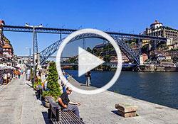
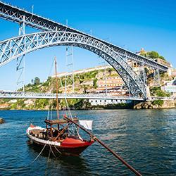
Due to the need for a permanent link between the two banks of the Douro River, in 1806 the Ponte das Barcas was built, using 20 boats that were linked together with steel cables. Previously, in 1369, the city had already had a walkway made up of boats joined with iron chains, covered with wooden planks. However, the increase in traffic proved it necessary to build a permanent bridge and so, in 1843, the Ponte Pênsil was built. This bridge was dismantled with the building of the Ponte D. Luís in 1886. It is the oldest bridge in existence and was designed by the Belgian, Théophille Syrig, who had already worked with Eiffel in building the D. Maria Pia railway bridge. At the beginning, for several decades, the two decks (upper and lower) were only used as a road connection between Gaia and Porto and also between the north and south of the country. As the city gradually grew in size, in the second half of the 20th Century (from 1901 to 2000), this infrastructure began to be insufficient and so other bridges were built.
The Ponte Maria Pia, which was constructed by Gustave Eiffel between January 1876 and 4th November 1877, was the first railway bridge to connect the two banks of the Douro. As it only had one line, it was eventually found to be insufficient and in 1991 it was closed and replaced by Ponte de São João.
The Ponte da Arrábida is more recent and is the main link between the city of Porto and the south bank of the Douro River. Ponte do Freixo was built to ease the traffic of cars from the Ponte da Arrábida and Ponte D. Luís I bridges, whilst the Ponte do Infante, baptised in honour of Infante D. Henrique (Henry the Navigator) is the most recent bridge linking Porto to Gaia and was built to replace the upper deck of Ponte D. Luís, which is now used as Metro do Porto's 'Yellow Line'. This bridge links Bairro das Fontainhas (Porto) to Serra do Pilar (Gaia).


20th Century (from 1901 to 2000) and 21st Century (from 2001 to 2100)
The monarch was overthrown in Portugal at the beginning of the 20th century and with the revolution of the 5th October 1910, the Republic was proclaimed. However, on 19th January 1919, the powers in favour of restoring the monarchy launched a counter-revolution in Porto, which they called the 'Monarchy of the North'. At that time, Porto became known as the capital of the restored kingdom, but the monarchy was quickly overthrown and no other monarchical revolution has taken place in Portugal since.
In its more recent history, Porto is still renowned for its wines, not only the Port wine but also table wines, which have come a long way and won various awards.
It is in this city, as the capital of the district and head of the municipality, that we can find the head offices of the country's major economic groups from various sectors such as banking, pharmaceuticals, food and automobiles (as is the case of the Salvador Caetano group). It is in the Metropolitan Area of Porto, more specifically in São João da Madeira, that the footwear and hat factories can be found, whose products are renowned all over the world.
The city of Porto, considered to be the capital of the North, is the capital of the district and as such encompasses 17 municipalities (Amarante, Baião, Felgueiras, Gondomar, Lousada, Maia, Marco de Canaveses, Matosinhos, Paços de Ferreira, Paredes, Penafiel, Porto, Póvoa de Varzim, Santo Tirso, Trofa, Valongo, Vila do Conde and Vila Nova de Gaia) and as the seat of the municipality, it comprises seven civil parishes (Bonfim, Campanhã, Paranhos, Ramalde, Aldoar, Foz do Douro e Nevogilde, Cedofeita, Santo Ildefonso, Sé, Miragaia, São Nicolau e Vitória, and Lordelo do Douro e Massarelos).
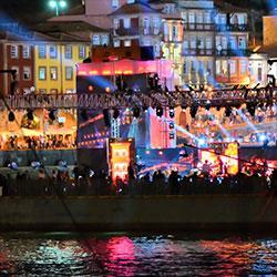
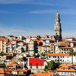
In 1996, the Historic Centre of Porto, which is the oldest urban area of the city, with signs of its mediaeval history, is comprised of the civil parishes of Sé, São Nicolau, Vitória and Miragaia. It was classified as Cultural Heritage of Humanity by UNESCO and even today, despite all the different eras and all the development that has taken place, the centre of Porto still maintains a faithful image of its past, with its narrow streets and old buildings, keeping kept all its character. You’ll be able to see parts of its identity in the various museums.
In 2010 and 2014, Porto was elected Best European Destination by the Best European Destinations' online election.
Also in 2014, the European Cities and Regions of the Future 2014/15 survey, carried out by the Financial Times, the respected British newspaper, put Porto in third place in the list of the ten most attractive cities in the south of Europe. To compile this list, this economic newspaper used indicators such as new infrastructures and spaces, the maintenance of the city, the promotion of its economy and the quality of life in the city. Another curiosity: in 2014 a survey carried out by the Smart brand of cars, in partnership with the RheinGold Institute, concluded that the people from Porto are the happiest inhabitants in Europe.
In 1994, in Vila Nova de Foz Côa, a city situated in the Alto Douro Wine Region, in the district of Guarda, in the land between the Douro River and the Côa River, Palaeolithic rock art figures were found, that are more than 20 thousand years old, proving that there was human occupation at that time. And since 1996, the Vale do Côa Archaeological Park has been organising visits to the engraving centre, in what has been classified as Heritage of Humanity by UNESCO, as it is the biggest museum of outdoor rock art in the world.